


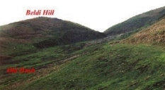
Beldi Hill lead smelt mill near Keld in Swaledale,

How we got to the Beldi Hill lead smelt mill.
A track from Keld goes through an area of distinctive beauty. It provides the shortest
walking route to the smelter. It rises up the side of a gorge/canyon on the Swale before
falling back to just above the level of the Swale again. However, though the distance is not
long, if you use this route, you need to be prepared to gain considerable height both going
to, and coming back from the Beldi Smelt Mill. Find the lovely cul-de-sac village of Keld
near the west end of Swaledale. Go to the end of the village, where you will see that a well
defined clear track leaves to the right. You will enter a car park if instead you go left. Come
back to the track and follow it a few hundred yards only before it divides. One side claims
the high ground but you need to bear left and make your way down to the Swale. The Swale
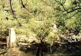
here is very picturesque. You will see where it has undercut the rocks, especially if you view
from the wooden bridge which you will need to cross.
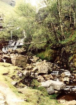
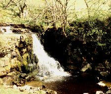
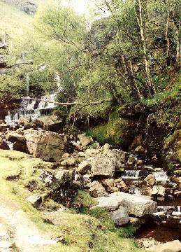
The water of Swinnergill can seen be coming down a waterfall behind the mill. The
Swinnergill valley can be seen opening out beyond the narrow gorge.
You will first need to skirt the falls going upwards at the left,
then turn right to the track above them.
Next, keeping right, you enter the track
which if followed along the side of this
superb Swale gorge will eventually lead to
Beldi Hill Mill.
On the way, the track gains height until
it passes Beldi Hill itself at the left.
There is then a z-bend where the track
crosses Oldfield Hush on a causeway.
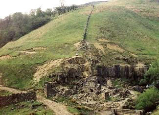
There are various old hushes near Beldi Hill, evidencing lead workings here long before the
mines were driven. Oldfield Hush pictured above is very large and looks to have been
created in a pre- existing rift. The energetic may feel like going up Oldfield Hush to search
out the lead workings higher up and the remains of the dams which used to collect the water
for hushing. Where lead veins were near enough to the surface on a hill, and assuming water
could be collected in a dam at the top, then the dam coud be burst so that the water would
rush down the hill exposing more lead.
Continuing on the track, one soon discovers an area of considerable spoil and some old
buildings. The building nearer the track is Crackpot Hall which, at the time (2003)had had
some then recent maintenance work done. It is possible here to branch off to the left and
extend your trip to take in also, the Swinnergill smelting mill.
We continued to Beldi Hill lead
smelter (smelt mill), following
the track by the wall. The track
descended rapidly to
Swinnergill, to a point not far
before where it joins the Swale.
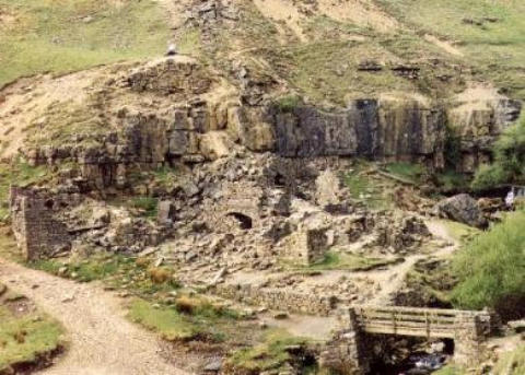
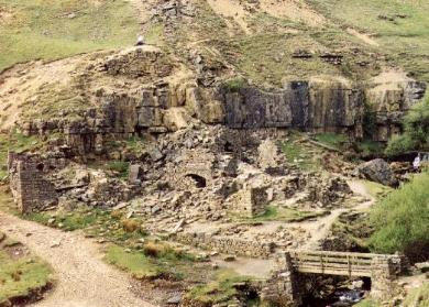
The Beldi Hill lead smelting mill
is just by the track on the left
bank of Swinnergill. It is clear
that the mill was built in a very
attractive location with a
waterfall behind.
Seen in 2003, efforts had been made to shore up the ore hearth
arch by erecting a column of stones underneath the arch's sagging
west side. Let us hope this succeeded.
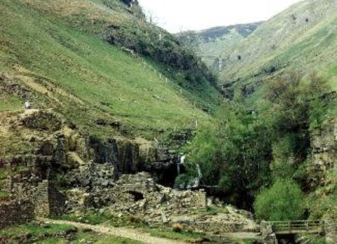
The setting.
Beldi Hill lead smelter was built at the side of Swinnergill to
provide its water power.
Swinnergill flows through a narrow gorge before reaching the
smelter site. There is a waterfall just above the mill. This and the
limestone cliffs to its side provide the mill
with a particularly attractive setting. Below the mill, the little
canyon opens out to enter Swaledale valley proper.
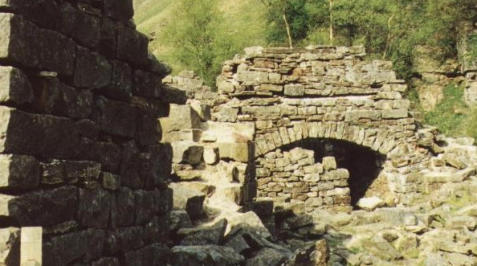
A long external flue.
In the picture at right, the external flue can be seen
clearly on the hillside.
We understood that the mill may have ceased productio in the early 1870s.
Link to the page on the Blakethwaite Smelt Mill >>>

N.B. Narrative and pictures are as of the times when the pictures were originally added (mostly 1997 to
2004). In 2021, things may look different; conditions, tracks and rights of way may have changed.
Click on the Home button for more explanation


Beldi Hill lead smelt mill near Keld
in Swaledale, Yorkshire Dales.
N.B. Narrative and pictures are as of the times when
the pictures were originally added (mostly 1997 to
2004). In 2021, things may look different; conditions,
tracks and rights of way may have changed.
Click on the Home button for more explanation.
How we get to the Beldi Hill
lead smelt mill.
The track from Keld goes through an
area of distinctive beauty. If you want to
get there, we think it provides you with
the shortest walking route to the smelt
mill. The route rises up the side of a
little gorge/canyon on the Swale before
falling back to just above the level of the
Swale again. However, though the
distance is not long, you need to be
prepared to gain considerable height
both going to, and coming back from
the smelter. Find the lovely cul-de-sac
village of Keld near the west end of
Swaledale. Go to the end of the village,
where you will see that a well defined
clear track leaves to the right. You will
enter a car park if instead you go left.
Come back to the track and follow it a
few hundred yards only before it
divides. One side claims the high
ground but you need to bear left and
make your way down to the Swale. The
Swale here is very picturesque. You will
see where it has undercut the rocks,
especially if you view from the wooden
bridge which you will need to cross.
The water of Swinnergill can seen be
coming down a waterfall behind the
mill. The Swinnergill valley can be seen
opening out beyond the narrow gorge.
You will first need to skirt the falls
going upwards at the left,
then turn right to the track above them.
Next, keeping right, you enter the track
which if followed along the side of this
superb Swale gorge will eventually lead
to Beldi Hill Mill.
On the way, the track gains height until
it passes Beldi Hill itself at the left.
There is then a z-bend where the track
crosses Oldfield Hush on a causeway.
There are various old hushes near Beldi
Hill,evidencing lead workings here
before the mines were driven.
Oldfield Hush pictured above very large
and looks as though it was created in a
pre-existing rift. The energetic may feel
like going up Oldfield Hush to search
out the lead workings higher up and the
remains of the dams which used to
collect the water for hushing. Where
lead veins were near enough to the
surface on a hill, and assuming water
could be collected in a dam at the top,
then the dam coud be burst so that the
water would rush down the hill
exposing more lead.
Continuing on the track, one soon
discovers an area of considerable spoil
and some old buildings. The building
nearer the track is Crackpot Hall which
has had some
maintenance
work done
recently. It is
possible here to
branch off to the
left and extend
your trip to take
in also, the
Swinnergill
smelting mill.
We continued to
Beldi Hill lead smelter (smelt mill),
following the track by the wall. The
track descended rapidly to Swinnergill,
to a point not far before where it joins
the Swale.The Beldi Hill lead smelt mill
is just by the track on the left bank of
Swinnergill.
It is clear that the smelter was built in a
very attractive location with a waterfall
behind.
Seen in 2003, the efforts made to shore
up the ore hearth arch by erecting a
column of stones underneath the arch's
sagging west side. Let us hope this
succeeded.
The setting.
Beldi Hill lead smelter was built at the
side of Swinnergill to provide its water
power. Swinnergill flows through a
narrow gorge before reaching the
smelter site. There is a waterfall just
above the mill. This and the limestone
cliffs to its side provide the mill with a
particularly attractive setting. Below
the mill, the canyon opens out to enter
Swaledale valley proper.
In the picture at right, the external flue
can be seen clearly on the hillside.
The mill may have ceased production in
the early 1870s.
Link to the page on the Blakethwaite
Smelt Mill >>>